How a Glacier, a Fjord, and a Mistake Became a Diplomatic Crisis
What Heilprin Land reveals about science, sovereignty, and the making of Greenland — and why those forces still shape Arctic power politics today.

Part 1 of a five-part series on science diplomacy and sovereignty in the Arctic.
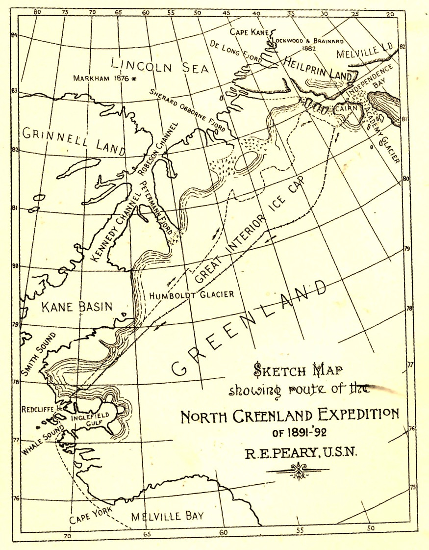
INTRODUCTION: On a clear Arctic day, Heilprin Land looks less like territory than memory: a high, wind-scoured plateau where rust-colored sandstone breaks through the ice sheet like exposed bone. There are no settlements, no roads, no flags. Yet for more than a century, this remote corner of northern Greenland quietly influenced the way nations argue about sovereignty, science, and power. Long before satellites, treaties, or climate models, Heilprin Land became something of a proving ground for a more elemental question — whether facts, once measured and mapped, could decide the fate of a place. Today, as Greenland returns to the center of global politics, driven by U.S. security concerns, rising Chinese and Russian Arctic activity, and the opening of mineral and shipping frontiers under climate change, that question has come back with it.
A brief author’s note appears at the end of this article.
Heilprin Land: Where Science Became a Claim
Heilprin Land occupies an odd position in the geography of global politics. Physically, it is ancient; its bedrock dates back roughly 1.38 billion years, part of the Mesoproterozoic story of a planet still assembling its continents. Politically, it is modern, having entered the world’s maps during an era when science, exploration, and national ambition were inseparable.
The land’s significance does not lie in what happened there, as no decisive battle was fought on its plateau, but in how knowledge about it was produced, contested, and ultimately used to settle questions of sovereignty.
To understand why Heilprin Land matters now, it helps to begin not in Greenland, but in Philadelphia.
The Architect Behind the Explorer
Angelo Heilprin was not an explorer in the romantic sense. He did not disappear into the Arctic for years at a time, nor did he seek personal glory at the poles. What he did instead was arguably more consequential: he built some of the institutional machinery that made cutting-edge American exploration possible.
Born in Hungary and educated in Europe, Heilprin arrived in the United States as a child and became fluent in multiple languages and deeply versed in geology, geography, and natural history. He returned to Europe in 1876 for several years to complete his education, studying at Geneva and Florence, where he trained in painting, at the Royal School of Mines in London, and at the Imperial Geological Institute of Vienna. He also climbed in the Carpathian Mountains and spent six months with relatives in Russian Poland.
By the late nineteenth century, he had become a central figure at the Academy of Natural Sciences of Philadelphia, where he held senior posts, and a founder of the Geographical Society of Philadelphia. He also founded the American Alpine Club, taught geology in Philadelphia, and lectured at Yale. One of his professors, Thomas Henry Huxley, the famous biologist and Darwin advocate, recommended Heilprin to other leading academics as “longo intervallo the best man in my class.”
At a time when exploration depended less on governments than on networks of scientists, patrons, and learned societies, Heilprin functioned as a broker, translating curiosity into funding, ambition into logistics.
Robert Peary was his most famous beneficiary.
“From the year 1891 dates the beginning of those intimate relations between Angelo Heilprin and Robert E. Peary which so largely influenced the career of that great explorer. No one has been more emphatic in acknowledging his indebtedness, in the early stages of his undertakings, to the support of Angelo Heilprin than Peary himself,” Gustav Pollak writes in his 1912 book, Michael Heilprin and His Sons: A Biography.
“From the very first day when Lieutenant Peary presented himself at the Academy of Natural Sciences, Heilprin was greatly impressed with his bearing and his evident ability, and he determined to further in every possible way Peary’s projects, of whose entire feasibility he never entertained any doubt.”
In a handwritten letter found among the academy’s archives now hosted by Drexel University in Philadelphia, the academy’s secretary recorded on May 28, 1891, that the academy, “desirous of increasing knowledge,” had appointed Peary, a civil engineer, as “commander of an expedition for the exploration of North Greenland, accompanied by a party the members of which are to study during the summer of 1891, the physics and natural history of the region and to make collections representing the natural resources thereof.” The letter goes on to specify that the “complete sets of such collections and reports of observations” belong to the academy, for its museum and publications.
When Peary set out in 1891 to determine whether Greenland was an island or a peninsula, he did so with Heilprin’s backing. And when Peary vanished for over a year during that expedition, it was Heilprin who organized and personally led the 1892 relief mission to find him.
The story of the meeting with Peary on the ice cap became “one of the most dramatic chapters in the history of Polar expedition,” Pollak noted, and was recounted by Heilprin himself in his 1893 book, The Arctic Problem and Narrative of the Peary Relief Expedition.
More than collegial loyalty, this was reputational risk. If Peary had been lost, Heilprin’s standing and that of American Arctic science would have suffered a severe blow.
Peary survived. And when he later affixed Heilprin’s name to a vast stretch of North Greenland, the gesture carried weight far beyond gratitude. Peary also bestowed on Heilprin, who later became president of the Association of American Geographers, an engraved barometer and a pair of narwhal tusks, passed down to family.

Naming as Strategy
In 1892, Peary stood atop a promontory he called Navy Cliff and gazed across what he believed was a frozen channel slicing through the top of Greenland. He named it the Peary Channel, and on the far side he identified lands he believed to be separate islands, among them Heilprin Land and Peary Land.
The claim was electrifying. If Greenland were divided by a channel, then its northern reaches were not part of the Danish-settled mainland. Under the international law of the era, land not under “effective occupation” could be treated as terra nullius — available to the first nation capable of mapping and naming it.
Peary’s hypothesis was, at best, mistaken. At worst, it was strategic. Whether Peary believed this hypothesis or understood its implications remains debated.
By mapping and naming these regions, Peary was not merely describing geography; he was opening a legal pathway for American territorial claims. In the nineteenth century, maps were instruments of statecraft. To appear on one was to exist; to be named was to be claimable.
Denmark understood this immediately.
The Danish Countermove: Science as Defense
Rather than issue diplomatic protests, Denmark responded with an expedition.
The Danmark Expedition (1906–1908) was conceived explicitly to test Peary’s claims. It was a brutal undertaking, marked by loss of life and extreme hardship, but its scientific results were decisive. The so-called Peary Channel did not exist. What Peary had seen was Independence Fjord, a deep inlet that did not sever Greenland into separate landmasses.
This distinction mattered enormously. If Heilprin Land was connected to the Greenlandic mainland, then Denmark’s claim to sovereignty remained intact. Geography, not diplomacy, would decide the question.
By disproving the channel, Danish scientists closed the legal loophole Peary had inadvertently or deliberately opened. The episode became a canonical example of what would later be called effective occupation: the use of sustained scientific presence to demonstrate state authority.
In 1933, the Permanent Court of International Justice in The Hague would rely on precisely this logic in affirming Danish sovereignty over all of Greenland, citing scientific exploration as evidence of control. After the ruling, Norway, which had formally occupied and claimed parts of Eastern Greenland, accepted the decision.
The conflict had been resolved not by force, but by measurement.
From Patronage to Treaty
The resolution of the Heilprin Land question marked a transition in how science functioned politically. In the late nineteenth century, knowledge flowed through individuals: patrons like Heilprin, explorers like Peary. By the mid-twentieth century, it moved through treaties.
The 1951 Defense of Greenland Agreement between the United States and Denmark formalized this shift. Driven by Cold War imperatives, the treaty granted Washington extensive military access to Greenland, including what would become Thule Air Base (now Pituffik Space Base). Yet even this security arrangement rested on scientific foundations: meteorology, geophysics, and Arctic logistics made permanent presence possible.
Science was no longer a precursor to sovereignty. It had become its infrastructure.
Greenland Returns
For decades, Heilprin Land receded into obscurity, known mainly to geologists studying the ancient Inuiteq Sø Formation and the dark intrusions of the Midsommersø dolerites that record a billion-year-old tectonic past. But climate change has collapsed that distance between deep time and present politics.
As ice retreats, Greenland’s strategic profile has sharpened. New shipping routes, untapped mineral reserves, and renewed great-power competition have pulled the island back into geopolitical focus. U.S. interest today is not about discovery, since it already enjoys extraordinary military access, but about advantage: countering Russian Arctic activity, limiting Chinese influence, and securing access to critical minerals.
Climate change accelerated these pressures, and once again, science sits at the center, not as neutral observer but as arbiter of possibility.
The Lesson of Heilprin Land
What Heilprin Land ultimately reveals is science diplomacy’s anatomy more than its origin story. Knowledge confers power not because it persuades, but because it stabilizes reality. In the Arctic, where borders are invisible and access is difficult, the ability to define what exists and where has always been decisive.
Angelo Heilprin understood this intuitively. He believed that facts, once established, could redirect ambition, temper hubris, and prevent catastrophic error. He testified before Congress against a Nicaraguan canal, arguing instead for Panama. What Pollak described as “the influence of Professor Heilprin’s scientific authority upon the debates in the Senate concerning the proposed inter-oceanic canal” was captured in a speech given by Louis E. Levy, a chemist and inventor of photoengraving processes, in a 1907 commemoration of Heilprin at Philadelphia’s Franklin Institute.
“The respective merits and difficulties of these two routes had been debated for years by experienced engineers, by learned geologists, by journalists and by statesmen, and when the choice was finally to be made by act of Congress, the Senate wavered in its decision, many of its members remaining undecided in their opinion,” Levy said.
It was at this point, Levy recounted, that Heilprin, who had recently returned from a groundbreaking, daring ascent of the erupting volcano Mont Pelée in 1902, announced his conclusion that it would be “absurd” to build the canal in Nicaragua, a volcanic country with only an assumed dormancy and untested resistance to a volcanic eruption’s destructiveness.
“The effect of this announcement was decisive. It brought conviction to the minds of Senators who had remained unconvinced … and left the Nicaragua project but a small minority of supporters,” Levy concluded. “But it was not only in Congress that Heilprin’s authoritative announcement brought conclusion to this much vexed question. His investigations influenced public opinion on the subject throughout the country and settled it permanently in favor of the Panama route.”
Heilprin published global syntheses of scientific knowledge decades before such work was fashionable. And in the Arctic, his name became attached to a place where truth itself became a geopolitical instrument.
As Greenland once again becomes a canvas for competing visions of the future, Heilprin Land reminds us that science diplomacy is an old discipline, forged in cold places, where maps mattered more than speeches — and where getting the facts wrong could change the world. On Heilprin Land, the rocks never moved. Everything else did.
Author’s Note: Angelo Heilprin (March 31, 1853 – July 17, 1907) was a relative of the author. The archival materials, books, and correspondence referenced here form part of an ongoing research project on his life and work.
This five-part series will continue weekly on Wednesdays.
Coming Next
If Heilprin Land entered global politics quietly, through a cartographic error, it remained there because the 20th century transformed the Arctic from a question of maps into a question of machines. In Part 2, this series follows Greenland’s shift from exploration to infrastructure: how Cold War science, military systems, and permanent technical presence replaced naming and mapping as the primary instruments of power, and why that legacy still shapes Arctic governance today.
Part 2: The Transition from Map to Machine — How Cold War Science Turned Greenland into Infrastructure


